Sunday, 7 November 2010

London Greenwich – 30th Sep 2010


Greenwich is best known for its maritime history and for giving its name to the Greenwich Meridian (0° longitude) and Greenwich Mean Time. The town became the site of a Royal palace, the Palace of Placentia from the 15th century, and was the birthplace of many in the House of Tudor, including Henry VIII and Elizabeth I. The palace fell into disrepair during the English Civil War and was rebuilt as the Royal Navel Hospital for Sailors by Sir Christopher Wren. These buildings became the Royal Naval College in 1873, and they remained an establishment for military education until 1998 when they passed into the hands of the Greenwich Foundation. The historic rooms within these buildings remain open to the public; other buildings are used by University of Greenwich and the Trinity College of Music. The maritime connections of Greenwich were celebrated in the 20th century, with the sitting of the Cutty Sark next to the river front, and the National Maritime Museum in the former buildings of the Royal Hospital School in 1934. Greenwich formed part of Kent until 1889 when the County of London was created.

Old Royal Navel College – Wren’s Stately structure was built in two houses so the Queen’s House would keep its river view. The buildings were built on the site of the old royal palace, where Henry VIII, Mary I and Elizabeth I were born. Only the chapel, the hall are open to the public.  


The great painted hall - 


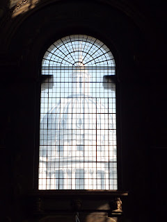
The Chapel -  


Looking towards the Thames between the two Old Royal Navel college buildings: 


Queen’s House – this house was designed by Inigo Jones and was completed in 1637. It was originally meant to be the home of Anne of Denmark, wife of James I, but she died while it was still being built and it was finished for Charles I’s queen Henrietta Maria. In 2001 it was refurbished and opened to the public housing art collections from the National Maritime museum.


Royal Observatory – The meridian (0 degree longitude) that divides the Earth’s eastern and western hemisphere passes through here. Furthermore, in 1884, Greenwich Mean Time became the basis of time measurement for most of the world.  The original building, the Flamsteed house, was designed by Christopher Wren.

Old Royal Observatory upo:  n the hill of Greenwich Park - 


Looking down from the Royal Observatory -


Greenwich mean time -


The meridian line -


National Maritime Museum – A history of Britain’s relationship with the Seas


Canary Wharf - is built on the site of the West India Docks on the Isle of Dogs. From 1802, the area was one of the busiest docks in the world. By the 1950s, the port industry began to decline, leading to the docks closing by 1980. Canary Wharf itself takes its name from No. 32 berth of the West Wood Quay of the Import Dock.

The first buildings were completed in 1991 which included One Canada Square that became the UK's tallest building and a powerful symbol of the regeneration of Docklands. Upon opening, the London commercial property market had collapsed and Olympia and York Canary Wharf Limited filed for bankruptcy in May 1992.


Thursday, 4 November 2010

Manchester Trafford Centre – Oct 2010

The Trafford Centre is a large indoor shopping centre and leisure complex located in the Greater Manchester. It is popularly known for its vivid and quirky resemblance to a rococo/late baroque architectural style. The centre is the 6th largest shopping centre in the UK by retail size. It also boasts Europe's largest food court in the Orient hall and the UK's busiest cinema.


The Orient - primarily a 1,600-seat food court which is mainly themed on a ship but incorporates themed designs from around the world including China, New Orleans, Egypt, Italy, America and Morocco.


The Great Hall - houses an elegant sweeping staircase featuring hundreds of metres of marble balustrade from China, and the largest Chandelier in the world. The chandelier has three levels of plant walkways inside, is around 11 m (36 feet) wide and 15 m (49 feet) high, weighs around five tonnes, and has more lighting control systems than most shopping centres.


Barton Square - Barton Square is located to the west of the main building and is linked to the rest of the centre via a glazed bridge. The architecture is based on an Italian square and includes a large fountain as well as a campanile tower.


Xmas at Trafford Centre – there is always really good decorations at the centre when it come to Christmas time


Macclesfield – October 2010

Macclesfield is a market town within the county of Cheshire, England, with a population of about 50,688. A person from Macclesfield is sometimes referred to as a "Maxonian". 

A brief bit of history:

Mentioned in the Doomsday Book of 1183, it is thought that Macclesfield got its name from "Michael's field" - referring to St. Michael, as in the St. Michael's church. Later, Macclesfield was granted a borough charter by the Lord Edward, the future King Edward I in 1261. The parish church of St Michael was built in 1278, an extension of a chapel built in approximately 1220.

Macclesfield was the administrative centre of the later Hundred of Macclesfield, which occupied most of east Cheshire. The Earl of Chester's manor of Macclesfield was very large, and its boundary went as far as Disley. The manor house was situated on the edge of the deer park, on the west of the town.


At one point, Macclesfield was the world's biggest producer of finished silk; now, the four Macclesfield Silk Museums display a huge range of information and products from that period. At one time the silk manufacture was home-based but as machinery was introduced large sheds were built to accommodate it and the workers were expected to move into them. 

Macclesfield is said to be the only Mill Town left unbombed in the Second World War.


Geography: 

Macclesfield is located in the east of Cheshire, on the River Bollin, a tributary of the River Mersey. It is close to the county borders of Greater Manchester to the north, Derbyshire to the east and Staffordshire to the south. It is near the towns of Stockport to the north, Buxton to the east, and Congleton to the south. To the west of the town lies the Cheshire Plain and to the east lie the hills of the Peak District.

Sun set over Macclesfield with a view east towards the Peak District: